


Latest Updates
Introducing the QCity Plugin
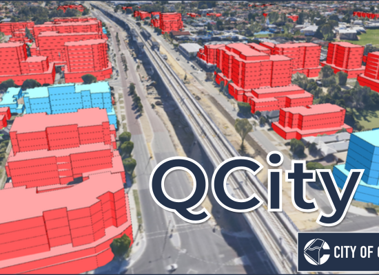
Urban Development Modelling in QGIS Introducing QCity, a new plugin that brings advanced urban development modeling directly into QGIS. Developed in collaboration with the City of Canning (Perth, Western Australia), QCity enables urban planners to model project areas using predefined frameworks, providing visual 2D/3D insights and detailed statistical reports. The plugin workflow begins in the “Project Setup” tab, where users either define a new Project Area boundary and input dwelling and parking (both car and bike) parameters, or load a previously saved site or QCity package: Next, “Development Sites” are created within each Project Area. Development Sites options include: Setting the site’s status: constructed, proposed or modelled Automatic calculation of the site’s floor space, car and bike parking (based on […]
QGIS 3D Globe – funded by a Cesium Ecosystem Grant
Open source geospatial 3D innovation has just reached another important milestone, thanks to a Cesium Ecosystem Grant for a new 3D globe view in QGIS. This is the second grant that the team of North Road and Lutra Consulting received from Cesium, and we’re proud of what we’ve delivered for our QGIS users. The new 3D globe will be available to all in QGIS v.3.44. This was an extremely interesting project to undertake, as it required a heavy research and experimentation process by our developers. There’s many potential approaches for implementing a large-scale, 3D globe, and each have their advantages and trade-offs. We were very lucky to have insight from Cesium’s Kevin Ring to advise us at the start […]

QGIS 3D Tiles – thanks to Cesium Ecosystem Grant!
We’ve recently had the opportunity to implement a very exciting feature in QGIS 3.34 — the ability to load and view 3D content in the “Cesium 3D Tiles” format! This was a joint project with our (very talented!) partners at Lutra Consulting, and was made possible thanks to a generous ecosystem grant from the Cesium project. Before we dive into all the details, let’s take a quick guided tour showcasing how Cesium 3D Tiles work inside QGIS: What are 3D tiles? Cesium 3D Tiles are an OGC standard data format where the content from a 3D scene is split up into multiple individual tiles. You can think of them a little like a 3D version of the vector tile format […]